| Field | Value |
|---|---|
Title |
High Ecological Value Waterways and Water Dependent Ecosystems - WAVERLEY LGA |
Alternative title(s) |
HEVwater WAVERLEY LGA |
Abstract |
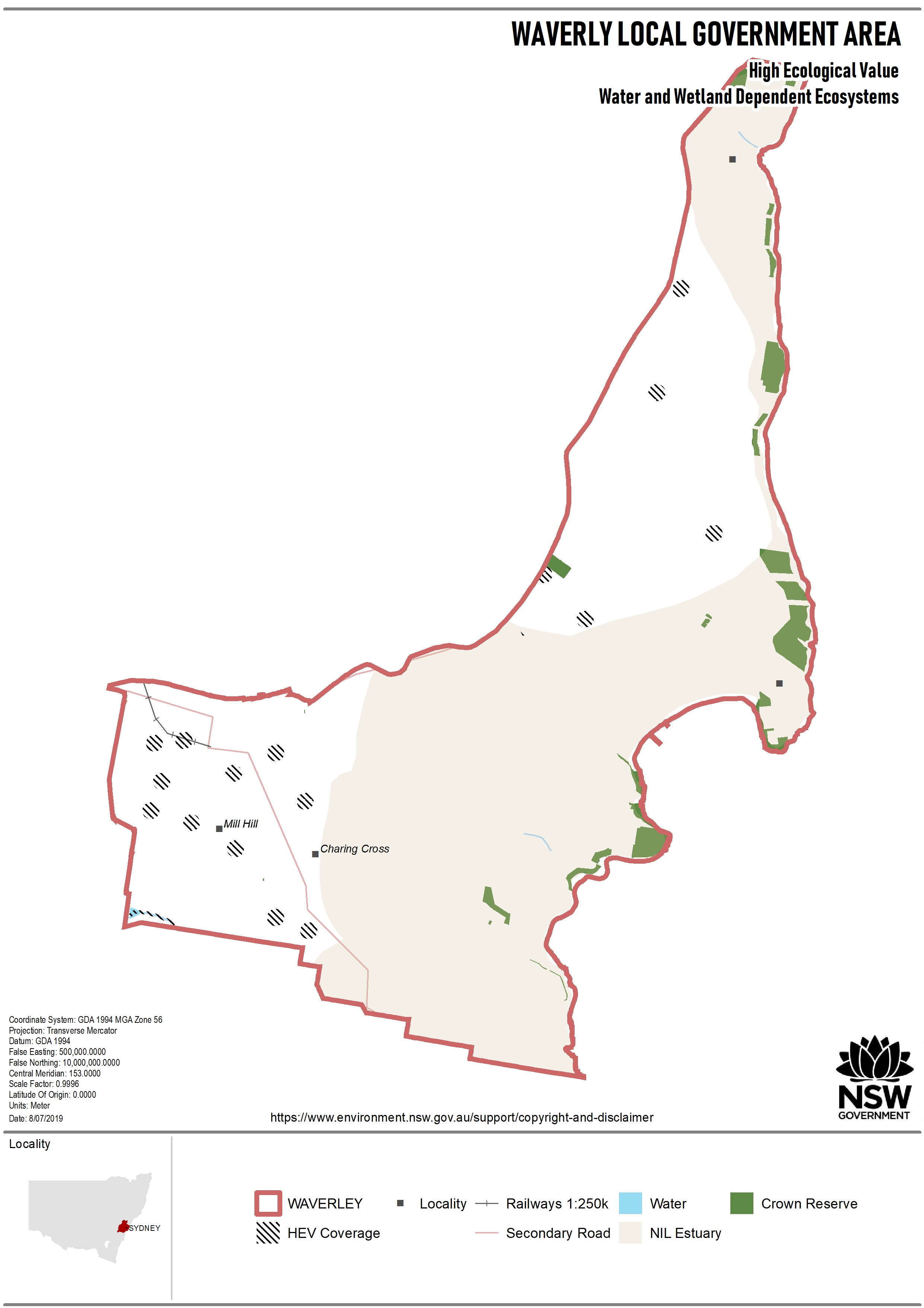
A map of the high ecological value waterways and water dependent ecosystems for the Waverley LGA was prepared by the Science Division of the Department of Planning, Industry and Environment, with input layers and support for the map provided by the former NSW Department of Primary Industries-Fisheries and Department of Industry-Crown Lands and Water. The basis for the map arises from Science Division inputs to strategic planning processes. For example, the map has been included in the Land Use and Infrastructure Implementation Plans for the Wilton (Wilton2040, page 22) and Greater Macarthur (interim plan, page 36) Priority Growth Areas. This map was specifically developed for input to Local Government Local Strategic Planning Statements to support Council’s delivery of Strategy 25.1 of the Greater Sydney Region Plan. The map shows areas where waterways and water dependent ecosystems are defined as high ecological value, based on definitions, guidelines and policies under the Environment Protection and Biodiversity Conservation Act 1999, Biodiversity Conservation Act 2016, Fisheries Management Act 1994 and Water Management Act 2000. Water dependent ecosystems are defined as wetlands, and flora and fauna that rely on water sources (including groundwater). The map represents an overlay of 39 indicators being used by the State Government to define high value, however, not all 39 indicators will be present in any one LGA (see Attachment 1 below). For example, there are 3 indicators making up the map for the Waverley LGA. It should also be noted that the individual indicators have not been ground-truthed and it is recommended that field assessments and/or a comparison to local mapping be undertaken prior to any decisions being made. The map was created by initially placing a 1 ha (to correspond with a lot size) hexagon grid over the LGA, and attributing the grid with the area, length and/or frequency of occurrence of high value water dependent ecosystems. The purpose of the map is to identify strategic planning priorities for protecting and improving the health of high value waterways and water dependent ecosystems in the LGA. Once identified, the priorities can be used as a basis for identifying aquatic biodiversity refugia, stream rehabilitation efforts and setting management targets and/or land use planning controls that would protect or improve the health of waterways and water dependent ecosystems so they provide the essential services and functions expected of a cool blue-green corridor. |
Resource locator |
|
Data Quality Statement |
Name: Data Quality Statement Protocol: WWW:DOWNLOAD-1.0-http--download Description: Data quality statement for High Ecological Value Waterways and Water Dependent Ecosystems - WAVERLEY LGA Function: download |
HEVwater WAVERLEY LGA |
Name: HEVwater WAVERLEY LGA Protocol: WWW:DOWNLOAD-1.0-http--download Description: This file contains ESRI format shapefile and jpg coverage map output. Function: download |
HEVwater WAVERLEY LGA map |
Name: HEVwater WAVERLEY LGA map Protocol: WWW:DOWNLOAD-1.0-http--download Description: This file presents the HEVwater coverage within the Local Government Area. Function: download |
Attachment 1_Waverley LGA Indicators |
Name: Attachment 1_Waverley LGA Indicators Protocol: WWW:DOWNLOAD-1.0-http--download Description: Datasets describing high value waterways and water dependent ecosystems in the Waverley LGA Function: download |
Unique resource identifier |
|
Code |
db5e0872-5ca4-420e-a5d8-07594d9b3033 |
Presentation form |
Map digital |
Edition |
1 |
Dataset language |
English |
Metadata standard |
|
Name |
ISO 19115 |
Edition |
2016 |
Dataset URI |
https://datasets.seed.nsw.gov.au/dataset/db5e0872-5ca4-420e-a5d8-07594d9b3033 |
Purpose |
Local Government Local Strategic Planning Statements |
Status |
Completed |
Spatial representation |
|
Type |
vector |
Geometric Object Type |
complex |
Spatial reference system |
|
Code identifying the spatial reference system |
4283 |
Spatial resolution |
100 m |
| Field | Value |
|---|---|
Topic category |
| Field | Value |
|---|---|
Keyword set |
|
keyword value |
WATER WATER-Wetlands WATER-Hydrology WATER-Groundwater MARINE-Coasts MARINE-Estuaries ECOLOGY-Ecosystem |
Originating controlled vocabulary |
|
Title |
ANZLIC Search Words |
Reference date |
2008-05-16 |
Geographic location |
|
West bounding longitude |
151.24079 |
East bounding longitude |
151.28626 |
North bounding latitude |
-33.91107 |
South bounding latitude |
-33.85703 |
NSW Place Name |
WAVERLEY LGA |
Vertical extent information |
|
Minimum value |
-100 |
Maximum value |
2228 |
Coordinate reference system |
|
Authority code |
urn:ogc:def:cs:EPSG:: |
Code identifying the coordinate reference system |
5711 |
Temporal extent |
|
Begin position |
2019-07-26 |
End position |
N/A |
Dataset reference date |
|
Resource maintenance |
|
Maintenance and update frequency |
As needed |
Contact info | |
Contact position |
Data Broker |
Organisation name |
NSW Department of Climate Change, Energy, the Environment and Water |
Telephone number |
131555 |
Email address |
|
Web address |
https://www.nsw.gov.au/departments-and-agencies/dcceew |
Responsible party role |
pointOfContact |
| Field | Value |
|---|---|
Lineage |
Original linage source data has been utilised in the preparation of the HEVwater Integrated layers for each of the LGAs within the Greater Sydney Region. |
| Field | Value |
|---|---|
Limitations on public access |
|
| Field | Value |
|---|---|
Scope |
dataset |
DQ Completeness Commission |
|
Effective date |
2019-07-26 |
Explanation |
Dataset from Bionet is based on set date range. Data may contain duplicated sightings for same species within a single location. |
DQ Completeness Omission |
|
Effective date |
2019-07-26 |
Explanation |
Dataset for Vegetation may contain absent species. No consistent and single vegetation layer is currently available. Vegetation is derived from multiple sources and dates. |
DQ Topological Consistency |
|
Effective date |
2019-07-26 |
Explanation |
Topological characteristics of the dataset is consistent with the source data used to derive the HEVwater products. Geodatabases have been used to ensure some accuracy is maintained throughout the process. |
DQ Absolute External Positional Accuracy |
|
Effective date |
2019-10-03 |
Explanation |
Limited ground truthing of individual attributes have taken place in the South Creek/Wianamatta catchment via direct field assessments in 261 sites and this has found that the overall map of 'High Ecological Value Waterways and Water Dependent Ecosystems' has an accuracy of >80%. However, it is recommended that ground truthing of the map for your local LGA be undertaken prior to any decisions being made. |
| Field | Value |
|---|---|
Responsible party |
|
Contact position |
Data Broker |
Organisation name |
NSW Department of Climate Change, Energy, the Environment and Water |
Telephone number |
131555 |
Email address |
|
Web address |
https://www.nsw.gov.au/departments-and-agencies/dcceew |
Responsible party role |
pointOfContact |
| Field | Value |
|---|---|
Metadata point of contact |
|
Contact position |
Data Broker |
Organisation name |
NSW Department of Climate Change, Energy, the Environment and Water |
Telephone number |
131555 |
Email address |
|
Web address |
https://www.nsw.gov.au/departments-and-agencies/dcceew |
Responsible party role |
pointOfContact |
Metadata date |
2024-02-26T13:31:21.641342 |
Metadata language |
|